
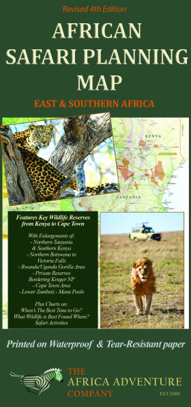
This map emphasizes the wildlife areas and provides information needed to plan a safari, whereas other maps on Africa focus on intricate road systems etc. which are irrelevant to most international safariers, as they either fly from park to park or they are driven by guides. Most other maps are basically useless from the standpoint of assisting readers in planning a safari.
The map includes the locations of over 150 top safari camps and lodges within key wildlife reserves that greatly assists in the planning of a safari of a life time!
Side 1 includes
- All the top safari countries and important wildlife reserves in East and Southern Africa
- "When's The Best Time to Go for Wildlife Viewing" chart – readers can conveniently choose the specific reserves and country(ies) that are best to visit during their vacation periods
- "What Wildlife is Best Found Where" chart – for choosing the reserves that have the wildlife readers wish to see most
- “Safari Activities” chart shows what reserves offer game drives in open vehicles, night drives, escorted walks, boating, canoeing, ballooning, mountain biking, horseback riding and fishing.
- Temperature and Rainfall Climate Rates charts show what weather to expect and the relative costs of a safari by season
Side 2 includes
Enlargements of the two key regions visited by most travelers including the locations of the top safari camps and lodges:
- The Okavango Delta (Northern Botswana) to Victoria Falls
- Northern Tanzania and Southern Kenya
- Route of The Great Serengeti Migration
- The Okavango Delta Flood (inundation)
- Enlargement of the Victoria Falls region

African Safari Planning Map
African Safari Planning Map
(4th ed.)

Product Details
| ISBN-13: | 9780939895298 |
|---|---|
| Publisher: | Global Traveler Publishers, Inc. |
| Publication date: | 08/19/2025 |
| Edition description: | 4th ed. |
| Product dimensions: | 4.25(w) x 9.00(h) x (d) |