

Devil's Gate: Owning the Land, Owning the Story
320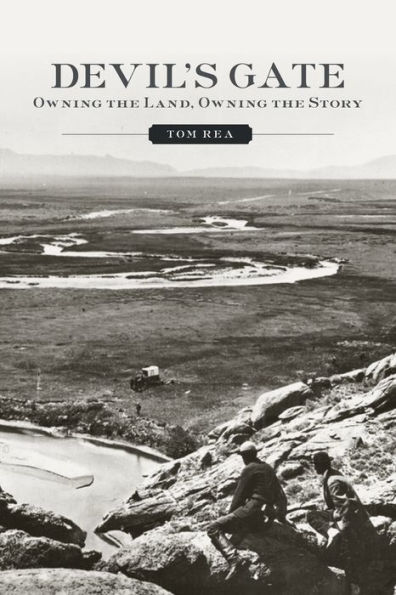
Devil's Gate: Owning the Land, Owning the Story
320Paperback(Reprint)
-
PICK UP IN STORECheck Availability at Nearby Stores
Available within 2 business hours
Related collections and offers
Overview

Product Details
| ISBN-13: | 9780806143682 |
|---|---|
| Publisher: | University of Oklahoma Press |
| Publication date: | 03/07/2013 |
| Edition description: | Reprint |
| Pages: | 320 |
| Product dimensions: | 5.90(w) x 8.90(h) x 0.40(d) |
About the Author
Read an Excerpt
Devil's Gate
Owning The Land, Owning The Story
By Tom Rea
UNIVERSITY OF OKLAHOMA PRESS
Copyright © 2006 University of Oklahoma PressAll rights reserved.
ISBN: 978-0-8061-8494-4
CHAPTER 1
Pelicans on the Sweetwater
The Casper Tribune said not long ago, if one saw a man coming down the street, with a cowboy hat on, wearing a business suit, and a pair of bright red boots, it surely was Bill Grieve. His brand was the Sunset.
—Ruth Beebe, 1973
Pelicans are fishing birds, and in the West they generally fly along rivers. Among those rivers is the Sweetwater, flowing down off the Continental Divide in Wyoming to join the North Platte about 100 miles to the east. The river got its name when some trader's sugar-laden pack mule, on fording, lost its footing and its load and sweetened the water for miles downstream. Or it got its name from the sweetish taste that the alkaline soil roundabout imparted to the water, or it got its name because the water wasn't alkaline and bitter but, rather, sweet, fresh, and pure. In any case, white travelers when they reached it from the east had just crossed fifty-five dust-dry miles of sagebrush steppe, with scarcely any water at all—and after a month or more following the brown and silty Platte. By then, any water would have seemed sweet, simply by being there.
But we were speaking of pelicans. In Wyoming we have the American white pelican, Pelecanus erythrorhynchos, and white they are, blazing white, with black wing tips and great orange-yellow bills. They are enormous, much bigger than the bald eagles that also coast our rivers, hunting fish; the pelicans' wings spread sometimes to nine and a half feet. Their grace, however, and their unanimity are more startling even than their size. They fly in flocks of two or three to fifteen or twenty. Like many species of smaller birds, but few of large ones, they can move in unison. Eagles fly mostly alone and, individualists that we think we are, we enjoy them for that. Pelicans fly together. They soar together, bank together, slide sideways and then spiral together up the thermals—so high sometimes they disappear. They never stray far from water, though. If a person has time and stays near the water, the pelicans will be back. They are common in central Wyoming along the North Platte and Sweetwater rivers, spring through fall. In winter, sensibly, they go south.
One place surpasses all others for pelican watching. Ten miles upstream from its mouth, the Sweetwater swings around a last meander, passes the corrals of the old Sun Ranch, and then abruptly cuts through a wall of granite. Just two hundred yards later, the river emerges again onto the sagebrush plain, meanders through the Dumbell Ranch, past Independence Rock and on east through sagebrush and alkali flats to a long arm of Pathfinder Reservoir. There, the Sweetwater's water first mingles with the waters of the North Platte.
Back where it flows through the granite, however, the river leaves a notch 360 feet high, a gunsight, a steep-sided, counterintuitive vee. For why wouldn't the river go around the granite wall? The wall ends only half a mile farther east. Surely so irresolute a stream, with its constant meanders and oxbows, its springtime sloughs and year-round willow thickets, would, when faced with an obstacle, choose detour over frontal assault?
Time is the answer; time, which feels no more constant in its flow than a western river in drought, still alters everything. It changes rocks, climate, birds, and people. It changes memory, and sooner or later it changes historical meaning. Seventy million years ago, near the end of dinosaur times, what's now Wyoming was low and flat, bordering a shallow sea that bisected North America from the Gulf of Mexico to the Arctic Ocean. Then the older granite underneath Wyoming began to be stressed from below. The North American land plate, floating then as now on the hot mantle underneath it, was moving north and west over a plate flooring the Pacific. The planet is always active where such plates grind and bump against each other; similar forces are pushing the Andes up today and threw up the terrible tsunami of Christmas 2004. Wyoming and the Rocky Mountains began to rise, oddly, when the pressure at one point released a little, allowing the rocks to bob upward, almost like marshmallows emerging from hot cocoa. Eventually, the Rockies rose far higher than their highest peaks now. Most of Wyoming's present mountain ranges were formed at this time—the Uinta Mountains in the southwest, the Medicine Bow Mountains in the south and southeast, and the Wind Rivers along the Continental Divide in the western half of the state, where the Sweetwater begins.
As uplift increases, erosion does, too; as slopes get steeper, streams get faster. Gradually, the basins between the new mountain ranges began filling with the sediment that the water brought down off them. Huge freshwater lakes formed in some of these basins; the water in them was crystal clear and very still. The air was warm and moist, and the Florida-like forests around the lakes were thick and subtropical. Then about fifty million years ago, enormous volcanoes arose in what's now northwestern Wyoming and filled the air with ash; the ash when it fell continued filling the basins between the mountains, burying trees, burying the lakes that had formed, and eventually burying the mountains themselves. Rivers that previously had flowed into the big lakes now flowed out of the filled-up basins, often right over the tops of the buried mountains. About ten million years ago a new round of mountain building began. The rivers, meanwhile, kept right on flowing, sawing indiscriminately from above through newer sediments and older granite. The new uplift together with the faster erosion that came with it carried away the softer sediments and re-exposed the hard granite mountains, notched and canyoned now by the newer rivers. The Sweetwater and North Platte, the Bighorn and Green rivers meander lazily across wide, nearly flat basins—until they come to the cuts through the mountains. Then the rivers get rocky and fast again. The Sweetwater does so just briefly at Devil's Gate, and used to do so again nearer its mouth, before its mouth was flooded by Pathfinder Reservoir. Similarly, the North Platte cuts through Fremont Canyon, the Green River dives through Flaming Gorge, and the Wind River boils through Wind River Canyon. A river might be expected to be steep near its source, then to flatten and slow gradually on the rest of its journey. Not in Wyoming. Our rivers move fast off the mountains, then slowly across basins, fast through new canyons, then again wind slowly across more basins. Like time in anyone's life, the rivers flow unevenly. In fact, they speed up and slow down for good reason. The world, that way, is orderly. People's lives are another matter.
As the mountains rose, the land dried out to the east of them in their rain shadow. By five million years ago, after the new round of mountain building, forests were shrinking on the east of the mountains as steppes and grasslands grew. Drought-tolerant plants moved in, including sagebrush, a newcomer from Asia by way of Siberia and Alaska.
Summers in Wyoming still smell like sagebrush, especially after a rain. But we never think of it as an Asian smell. It's sharp, clear, metallic, local; it's the smell of memory in the West, and the smell has the gray-green color of the sage leaves and of the skies that make the rain. Breeze, we say in summer; wind, we call it the rest of the year.
At Devil's Gate, the wind is chronic. "A drying wind blows almost continuously," Kathleen Sun wrote in 1986, after she'd lived on the Sun Ranch for forty years. And it's been doing so four million years longer than that. Not far to the west and south, the Continental Divide sags to its lowest point between Alaska and Mexico. That's why the Oregon Trail followed the Sweetwater to cross the Divide at South Pass, near the river's headwaters. South of the pass the Divide splits and is lower still—only about 7,000 feet—where I-80 and the Union Pacific Railroad now cross Wyoming. Like water, wind funnels through this low spot in the mountains. A narrow, 100-mile-long strip of sand dunes crosses the Red Desert north of and parallel to the interstate highway. If Mrs. Sun's testimony weren't enough, the dunes make it clear the wind has been blowing from the west for millions of years. The wind is still moving the dunes.
By two million years ago, the mountains and rivers in Wyoming lay about where they are now, and the plants were not so different—aspen and conifers on the mountain slopes, shrubs and grasslands in the basins and valleys, cottonwoods along the rivers. Then the world began to cool. The planet's icecaps grew enormously. The great continental ice sheets did not come as far south as Wyoming, but thick mountain glaciers came much farther down the mountainsides. Local and continental glaciers advanced and retreated many times. As they retreated, meltwater filled huge lakes. One drowned northwestern Utah; another filled the valleys of western Montana.
In Wyoming, glaciers scooped cirques in the granite walls at the head of mountain valleys and rounded the valleys themselves, from V- to U-shaped. Tundra covered the lowlands, permafrost was widespread, and the animals were arctic: lemmings, caribou, and musk ox. Mammoths roamed the intermountain basins. The ice in the mountains ground rock to dust. When the glaciers retreated, water and wind carried the dust off the mountains and out east toward the plains, where it was deposited as loess, enriching the soil and helping out the plants and animals. The richer soil makes for more grass and less sagebrush in northeastern Wyoming's Power River Basin. When the grass-rich basin became the last refuge of the great buffalo herds, it became the last refuge, too, of the people who followed the buffalo.
People had arrived in the basins and along the rivers by 11,000 years ago. Like the sagebrush millions of years earlier they, too, appear to have come from Asia—either across the Bering Strait and down a corridor that had opened through the glaciers, or down along the coast from Alaska in skin boats, or both. An Arapaho story tells of the people crossing a wide stretch of ice. A little girl and her grandmother were coming along near the tail end of the group when the girl saw a horn sticking up out of the ice. The girl wanted to make a doll with the horn, and her grandmother, to oblige the child, took a stone axe and began to chop it off. Blood flowed after a few strokes, and suddenly the ice began to heave and buckle: the horn was the horn of a huge sea monster, and the monster was rising up in pain. The people fled forward, but a few, farther back still from the girl and her grandmother, were left behind. No one knows what happened to the ones we left behind, the story goes—but far to the north there must still be others like us.
Their beautifully made spear points—all that survives of their intricate culture and competent lives—seem to show that people roamed the plains hunting big game on foot. The animals 11,000 years ago were enormous. Probably the people worked in small groups, ambushing prey at springs or streams, preferring the younger and smaller mammoths and butchering two or three at a time. As the people kept hunting, the world got slowly warmer and drier. Many of the big American mammals of the Pleistocene epoch—mammoths, mastodons, beavers the size of bears, giant ground sloths, rhinos, camels, cheetahs, sabertooth cats and horses—went extinct eleven or ten thousand years ago. By 9,500 years ago, lodgepole pines replaced spruce trees in the mountains. People learned to hunt the giant Bison antiquus in larger numbers, driving them over cliffs or into ravines or up into the ravinelike head of a parabolic sand dune, and killing them there. The warming and drying continued; drought-tolerant sagebrush, juniper, and grasses were expanding their range. Finally, the plains got so hot and dry that bison and people seem to have disappeared from them altogether. The drought began about 7,000 years ago and lasted 2,000 years.
Such an event dwarfs the seven-year, dust-bowl drought of the 1930s, or the current drought of the interior West that some now think the worst in 500 years, or the fifty-year and twenty-three-year droughts that scoured the West with cultural and biotic change in the twelfth and thirteenth centuries A.D. Climate swings are a way of life—and death—on the plains. The air that comes east over the Rockies, dry by the time it arrives, meets moist, warm air coming up from the Gulf of Mexico and cold, dry air coming south from the Arctic. These three forces never achieve a very stable equilibrium, nor, 1,200 miles from any ocean, are any moderating influences available. Sometimes, however, the normally volatile situation swings much farther out of balance. Distant changes in the regular circulation patterns of ocean and atmosphere weaken the prevailing westerlies, and result in long swings from dry to wet and back again as the northern air or southern air, for a time, dominates. The bison, during the drought, retreated far to the north. Some of the people followed them; others retreated from the plains to the coasts of the largest rivers, the Missouri and the Mississippi.
By about 4,500 years ago, people had returned, but with a new economy. Adversity appears to have made them generalists. They stayed in caves and rock shelters from time to time; they gathered plants and ground the seeds; they fished, and they hunted and ate small mammals, reptiles and amphibians. Far away to the north and east a bison economy persisted, and would eventually return. Also by that time the larger Bison antiquus appear to have been replaced by the modernBison bison, and from now on, we will call them by their familiar name: buffalo.
The world was cooling again, and the plains were looking much as they do now. Grass and shrubs, which had advanced partway up the mountainsides during the long drought, again grew primarily in the basins, and were replaced by conifers on the slopes. Wolves and pronghorn antelope had survived the Pleistocene extinctions, and buffalo slowly returned to the plains. Some people again found the old, nomadic hunting to be the most efficient way to make a living. People left tipi rings, pictures and carvings on rocks, and much larger stone circles oriented to the sun and stars. Hundreds of miles east, semi-permanent villages grew up along the Missouri, where people grew corn, beans, and squash in the river bottoms, and learned to make pottery in which they could store the seeds. Around 500 A.D. people began using bows and arrows. Trade grew up between the plains hunters and riverside farmers. After 1700, horses began arriving from the Spanish south, and steel tools, cloth, iron pots, mirrors, glass beads, and guns began arriving from the French and British northeast. And after that, everything that had been happening to the people for 11,000 years began to happen very fast. Change sped up a hundredfold.
The most dramatic place for watching pelicans is from the top of Devil's Gate. There, 360 feet above the river level, you could feel like a pelican yourself if able to leave the rocks and fly. You can see downstream past Independence Rock to the reservoir, and upstream to another granite landmark, Split Rock—thirty miles or more of the Sweetwater valley. Pelicans are most common along here in May. After the first of June, for some reason, they confine their foraging to the reservoir and to the Platte valley north and south of the reservoir. Home base is Bird Island, a narrow thirty-acre sage- and rabbitbrush-covered mound in what used to be a bay of the reservoir where Sand Creek flows into it from the southwest. There, chicks before they can fly are safe from foxes, coyotes, skunks, and people. Gulls, terns, cormorants, and a few black-crowned night herons nest on the island, too—but pelicans are by far the most numerous citizens. A state biologist counted 245 active nests on the island in 1984 and 384 nests in 1985; by the end of the 1990s, the annual census topped 1,200. In dry years, the U.S. Bureau of Reclamation allows the reservoir to fall very low, as its first job is to protect not the birds but the Nebraska irrigators 350 miles away who own the rights to the water. Bird Island then becomes a peninsula, or lately more like a part of the mainland. Most of the former bay is filled with dirt flats. Before the young pelicans can fly, coyotes, foxes and badgers can trot out there and eat their fill. But the pelicans are long-lived birds, and the colony can survive at least a season or two—perhaps more, perhaps not—when all their young are eaten.
The same biologist noted in his report that, despite their local success, white pelicans are declining. There may be as few as twenty colonies left throughout the West, down from perhaps three times that number. But they are newcomers in central Wyoming; as far as anyone seems to know, none nested on Bird Island before 1983. They like remote places where they can breed and nest undisturbed, and so perhaps they came here because they were crowded out of somewhere else.
(Continues...)
Excerpted from Devil's Gate by Tom Rea. Copyright © 2006 University of Oklahoma Press. Excerpted by permission of UNIVERSITY OF OKLAHOMA PRESS.
All rights reserved. No part of this excerpt may be reproduced or reprinted without permission in writing from the publisher.
Excerpts are provided by Dial-A-Book Inc. solely for the personal use of visitors to this web site.
Table of Contents
Contents
List of Illustrations,Acknowledgments,
Introduction. The Middle of Nowhere,
Chapter 1. Pelicans on the Sweetwater,
Chapter 2. Tenantless and Forlorn,
Chapter 3. The Pathfinder's Lost Instruments,
Chapter 4. A Road to Somewhere Else,
Chapter 5. Burning Bridges,
Chapter 6. Brigham's Curse,
Chapter 7. War,
Chapter 8. Hayden's Gaze,
Chapter 9. Grazing in Paradise,
Chapter 10. Township and Range,
Chapter 11. Neighbors,
Chapter 12. The Magic Touch of Water,
Chapter 13. Story Spots,
Chapter 14. Perfect Balance,
Epilogue. A Drying Wind,
Notes,
Bibliography,
Index,