

Paperback(Second Edition)
-
PICK UP IN STORECheck Availability at Nearby Stores
Available within 2 business hours
Related collections and offers
Overview
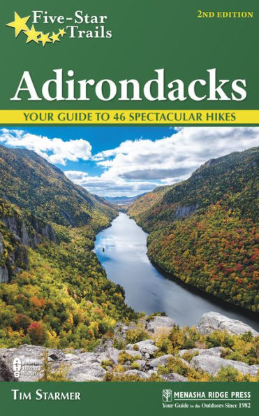
The Adirondack Park is an immense wilderness encompassing more than 9,375 square miles. Within its boundaries are rugged mountains, countless pristine lakes and ponds, seemingly endless forests, and thousands of miles of wild rivers, providing an infinite number of outdoor adventures. The revised edition of Five-Star Trails: Adirondacks, by Tim Starmer, features six new popular trails and provides a detailed guide to some of the most stunning views found across the Adirondacks. Included are rugged and steep ascents up Snowy Mountain in the Central Adirondacks, which many consider the 47th high peak, and isolated Debar Mountain in the northern Adirondack region. Distance hikers will love the long trek into the High Peak Wilderness to see the amazing Hanging Spear Falls along the Opalescent River.
Also new to this edition is the less difficult but equally scenic vistas of the Eastern Adirondacks and Lake George described along the Black Mountain trail. And delve back into the remote depths of the High Peaks region to explore unique trails with descriptions of Wright Peak, Avalanche Pass, and the second highest mountain in New York, Algonquin Mountain.
Each hike features an individual trail map, elevation profile, and at-a-glance information.

Product Details
| ISBN-13: | 9781634040525 |
|---|---|
| Publisher: | Menasha Ridge Press |
| Publication date: | 05/16/2017 |
| Series: | Five-Star Trails |
| Edition description: | Second Edition |
| Pages: | 360 |
| Sales rank: | 639,817 |
| Product dimensions: | 5.00(w) x 7.90(h) x 0.80(d) |
About the Author
Read an Excerpt
Stewart and Indian Lakes
Scenery: 3 stars
Trail Condition: 4 stars
Children: 5 stars
Difficulty: 1 star
Solitude: 5 stars
GPS Coordinates: N43° 10.790' W74° 30.295'
Distance & Configuration: 4.6-mile out-and-back
Hiking Time: 2–3 hours
Highlights: Two secluded lakes
Elevation: 1,603' at trailhead, 2,044' at highest point
Access: Open 24/7; no fees or permits required
Maps: National Geographic Adirondack Park, Northville/Raquette Lake (#744)
Facilities: None
Wheelchair Access: No
Contacts: Central and Southern Adirondack trail information: www.dec.ny.gov/outdoor /9200.html; emergency contact: 518-891-0235
Overview
This easy hike is a great destination for people who wish to explore two remote, picturesque lakes for fishing or a picnic. With a few moderate climbs, it is a good trail for children, and wildlife viewing at both lakes provides additional interest.
Route Details
Located in the Shaker Mountain Wild Forest, the trail uses old logging roads, so the grades are mostly gentle and easily accessible to hikers of all experience levels. The area had been heavily logged before state acquisitions, and much of the forest is still in a phase of regeneration. However, the acquisitions occurred decades ago, and traces of past logging have disappeared. Wild forest areas—in contrast to wilderness, primitive, or canoe areas—are considered less ecologically fragile, allowing for a greater variety of uses and more intensive activities. Don’t let the distinction fool you, though, as they are definitely wild places and provide excellent wilderness experiences. Access to the parking area is at the left fork along Green Lake Road, which appears to be little more than a driveway. The well-maintained and spacious lot provides parking for the Kane Mountain Trail as well, but it can easily accommodate a dozen cars, so space should not be a concern.
The trail begins to the right of the trail register on the north end of the parking lot. Shrouded in tall pines, it follows an access road to a small fish hatchery created by the damming of Otter Lake’s outlet, and you can hear water spilling over the concrete dam in most seasons. The trail diverges from the road shortly before the pond on your right. The exact path may be a little hard to discern, but a wooden bridge and a sign prohibiting the use of baitfish will steer you.
A note to anglers: The Department of Environmental Conservation has gone to great lengths to reestablish native brook trout and the endangered round whitefish in some of the isolated waters of the Adirondacks. Reestablishment methods vary but include treating entire lakes with rotenone to remove competing, nonnative species and then restocking the waters with native fish. Due to the physical characteristics of the various Adirondack waterways, the success of this technique is limited and expensive. When the technique is successful, those same physical characteristics mean there will be lasting success and that native fish populations can thrive. Unfortunately, the reintroduction of nonnative species is almost exclusively a consequence of the unintentional release of baitfish by anglers into the reestablished ecosystems. So leave the bait bucket at home when visiting the prized fishing waters of the Adirondacks.
Once on the trail, you will notice that it is emblazoned by yellow trail markers and very easy to follow the rest of the way. A quick climb takes you along a low ridge overlooking the pond to your left. The trail climbs through a mixed hardwood forest dominated by birch and beech trees. The grade is very moderate for the first 0.7 mile, at which point you encounter a muddy area. The trail climbs more steeply after this muddy area, but at approximately 1.2 miles it levels off to a more gently rolling terrain. Farther along the trail, the forest canopy gets higher and the understory thins, allowing deeper views into the surrounding forest. You catch glimpses of Stewart Lake as you approach 1.3 miles, where there is a fork in the trail. The main trail continues on the right toward Indian Lake, while the left fork takes you through a stand of pine and hemlock to a boggy area that surrounds Stewart Lake. The marshland prevents you from gaining direct access to the lake but makes for good wildlife viewing.
Back along the trail, you encounter some mucky areas that you will have to negotiate on your own, as no good way bypasses the muck. At 2 miles, you pass a thick carpet of club moss, which at first glance looks like tree saplings but is actually more closely related to ferns. At this point, you begin the descent to Indian Lake, where the trail ends at the shore. A path to the left follows the shoreline toward a rock that juts out into the lake and provides additional vantage points. The remote setting promises a wonderful opportunity to view a variety of wildlife, including a beaver lodge.
Directions
From the southern intersection of NY 10 and NY 29A in downtown Caroga Lake, head north on NY 10/NY 29A. At 3.4 miles past the intersection, turn right onto Green Lake Road.
From the intersection of NY 8 and NY 10 in Piseco, head 19.6 miles south on NY 10, and turn left (1.9 miles past the northern intersection of NY 10 and NY 29A near Pine Lake Park) onto Green Lake Road. Follow Green Lake Road north along the west edge of the shore. At 0.5 mile, bear left onto the parking area drive.
Table of Contents
Overview MapOverview Map Key
Dedication
Acknowledgments
Preface
Recommended Hikes
Introduction
Southern
1. Stewart and Indian Lakes
2. Good Luck Cliffs
3. Jockeybush Lake
4. Groff Creek
5. Tenant Creek Falls
6. Hadley Mountain
7. Crane Mountain
West-Central
8. Panther Mountain and Echo Cliffs
9. Mitchell Ponds
10. Bear and Woodhull Lakes
11. Black Bear Mountain
12. Bubb, Sis, and Moss Lakes
13. Cascade Lake
14. Gleasmans Falls
Central
15. Auger Falls
16. Shanty Brook
17. East Branch Sacandaga Gorge
18. Snowy Mountain
19. Chimney Mountain
20. Peaked Mountain
21. Castle Rock
22. Blue Ledges
23. Hoffman Notch
Eastern
24. Sleeping Beauty Mountain
25. Shelving Rock Falls
26. Black Mountain
27. Tongue Mountain Range
28. Pharaoh Mountain [day or overnight hike]
29. Pharaoh Lake [overnight hike]
Northern
30. Owls Head Mountain
31. Cat Mountain
32. High Falls [overnight hike]
33. Lampson Falls and Grass River
34. Floodwood
35. Saint Regis Mountain
36. Debar Mountain
High Peaks
37 Ausable River: West River Trail
38. Ausable River: East River Trail
39. Giant’s Nubble
40. Hanging Spear Falls and Opalescent River [day or overnight hike]
41. Indian Pass
42. Algonquin Peak
43. Avalanche Pass
44. Little and Big Crow Mountains
45. Pitchoff Mountain
46. Ampersand Mountain
Appendix A: Managing Agencies
Appendix B: Gear Lists
Appendix C: Hiking Clubs
Appendix D: Suggested Reading
Index
About the Author
Map Legend