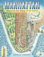
★ 06/24/2019
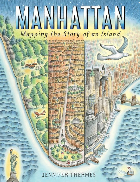
The latest cartographic picture book from Thermes (Charles Darwin’s Around-the-World Adventure) maps Manhattan Island’s evolution from a glacially carved, flora- and fauna-rich wilderness into a bustling New York City borough. Full-page pictorial maps—befitting the book’s large trim size—document Manhattan’s south-to-north transformation. Ink-and-watercolor illustrations in soft hues depict the progression from villages of the Native Lenape people (who called the island Mannahatta) to colonial Dutch and British settlements and, finally, to a dense, diverse, skyscraper-filled city. Stylized birds fly banners with straightforward spread titles while sidebars frankly delineate the detrimental practices and impacts that its growth wrought on Native, African-American, and immigrant populations: spreads about Central Park and its many amenities are preceded by one recounting how African-American Seneca Village was demolished to make way for it. Also covered are some of Manhattan’s other notable stories: how the city got its street grid and famous subway; memorable natural disasters that befell it; and vignettes of how prominent skyscrapers and bridges were built. Like Manhattan itself, much is packed into this handsomely illustrated history. Back matter includes an extensive timeline and selected source list, while endpapers show a complete map of the modern city. Ages 8–12. (Aug.)
"The history in the book is as much an abundance as its pictures . . . a splendid homage."
**STARRED REVIEW** "A fascinating account of New York City's development from the time of the Lenape people to the present day."
**STARRED REVIEW** "Thermes, also a map illustrator, shows off her skills with detailed maps that reveal the origins of Broadway, Wall Street, and other landmarks . . . This slice of American history is a gem."
**STARRED REVIEW** "The vibrant history that unfolds will hold children's attention through repeated viewings."—Kirkus Reviews
**STARRED REVIEW** "Thermes, also a map illustrator, shows off her skills with detailed maps that reveal the origins of Broadway, Wall Street, and other landmarks . . . This slice of American history is a gem."—Booklist
**STARRED REVIEW** "Like Manhattan itself, much is packed into this handsomely illustrated history."—Publishers Weekly
**STARRED REVIEW** "The maps, colorful illustrations, and accessible text present a comprehensive history of Manhattan as an island and a good introduction to the study of urban growth for students of all ages."—School Library Journal
**STARRED REVIEW** "A fascinating account of New York City's development from the time of the Lenape people to the present day."—Shelf Awareness
"The history in the book is as much an abundance as its pictures . . . a splendid homage."—The Horn Book
**STARRED REVIEW** "Thermes, also a map illustrator, shows off her skills with detailed maps that reveal the origins of Broadway, Wall Street, and other landmarks . . . This slice of American history is a gem."
★ 08/01/2019
Gr 3–7—Thermes presents the history of Manhattan from the time when glaciers covered the land to its contemporary prominence as a center of commerce, culture, and civilization through the use of maps, sidebars, and stories. From its hilly, swampy beginnings as a natural haven for birds and beavers to modern skyscrapers, subways, and parks, the island's unique history unfolds with colorful illustrations and accessible text. In the opening pages, Thermes reveals that Manhattan was originally home to the Lenape peoples and known as Mannahatta; she emphasizes the peoples who populated its ever-expanding boundaries. From the original Native peoples to the Dutch and English settlers to the countless immigrants and the African Americans who were enslaved, each group contributed to the city we know today. Much of the information offered concerns the natural world and the changes brought about by the ever-shifting needs of the populace. Surprisingly, although several natural catastrophes are shown, there is only a very brief mention of the 9/11 tragedy in the exhaustive time line offered in the appendix. A comprehensive bibliography suggests books, websites, museums, and a podcast for further information. VERDICT The maps, colorful illustrations, and accessible text present a comprehensive history of Manhattan as an island and a good introduction to the study of urban growth for students of all ages. Very valuable to students in the New York City metropolitan area, but also highly informative for all readers.—Eva Elisabeth VonAncken, formerly at Trinity-Pawling School, NY
★ 2019-05-26
Beavers, oysters, and elm trees; the Lenape people, those who were enslaved, and those who immigrated; and subways, skyscrapers, and Superstorm Sandy fill the pages of a street-by-street chronicle of this incredible island.
Thermes opens with glaciers and moves on through the Mannahatta of the Lenape clans and the Manhattan of the Dutch and the English. Central to the formatting of both the book and New York City is the Plan of 1811 that established a grid pattern for the streets of the island north of Lower Manhattan. Central Park is developed, tenements are built to house poor immigrants, subways and bridges expand the island to neighboring locales, and tall buildings fill the horizon. Thermes does not shy from the violence of the city's history, providing, for instance, an informative sidebar about Seneca Village, established by free blacks and destroyed by eminent domain to build Central Park. The highlights of the book are the many sequential maps, drawn in watercolor, pencil, and ink. They include, in very legible hand-lettering, street names and references to sites mentioned in the text. Horses, dogs, and young children, both white and of color, stroll along. Other pages vary from full-page vistas of Central Park, fires, subways, and snowstorms to spot art featuring bridges, birds, and the harbor.
The vibrant history that unfolds will hold children's attention through repeated viewings. (afterword, timeline, select sources) (Informational picture book. 7-10)


")
")
")


")


