

The Fall and Rise of the Wetlands of California's Great Central Valley
448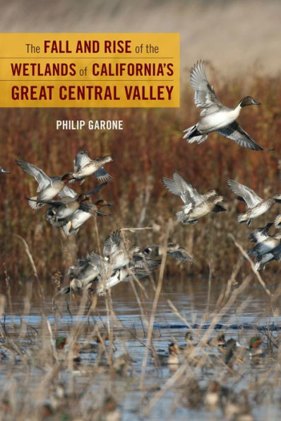
The Fall and Rise of the Wetlands of California's Great Central Valley
448eBook
Available on Compatible NOOK devices, the free NOOK App and in My Digital Library.
Related collections and offers
Overview

Product Details
| ISBN-13: | 9780520948495 |
|---|---|
| Publisher: | University of California Press |
| Publication date: | 04/10/2011 |
| Sold by: | Barnes & Noble |
| Format: | eBook |
| Pages: | 448 |
| File size: | 12 MB |
| Note: | This product may take a few minutes to download. |
About the Author
Read an Excerpt
The Fall and Rise of the Wetlands of California's Great Central Valley
By Philip Garone
UNIVERSITY OF CALIFORNIA PRESS
Copyright © 2011 The Regents of the University of CaliforniaAll rights reserved.
ISBN: 978-0-520-94849-5
CHAPTER 1
The Nature of the Great Central Valley and the Pacific Flyway
Before the arrival of European Americans, wetlands were present across the length and breadth of the Central Valley. Waterfowl and other waterbirds swam on the surface or stood in the shallows of permanent and seasonal freshwater marshes, which were renewed annually by the spring flooding of the valley's rivers. Thundering honks and quacks of enormous flocks of geese and ducks, descending from the sky or taking flight en masse from the water, revealed from afar the locations of these marshes, clustered in the low- lying and poorly drained basins (or troughs) of the valley. Ephemeral vernal pools and larger playa pools, filled with aquatic invertebrates and surrounded by brilliantly colored flowers, lay scattered amid millions of acres of native valley grasslands. Expansive riparian forests with their massive valley oaks, as well as evergreen oaks, cottonwoods, and sycamores, lined the major rivers and creeks, creating thick ribbons of green and vertical relief from the fl at valley floor. Within these seasonally flooded forests, herons, egrets, and cormorants roosted in colonies, and brightly colored wood ducks nested and raised their young in tree cavities.
Each of these three natural communities—freshwater marsh, valley grassland, and riparian woodland—either was defined by wetlands or contained a wetland element, and at least some of the plants and animals in each community were adapted to live in wetlands. Over the past two centuries, each community has been dramatically altered and numerous species of flora and fauna have been displaced, waterfowl not least among them. The history of each community therefore reveals a distinct component of the overall ecological transformation of the Central Valley and the disappearance of its wetlands.
VALLEY GRASSLAND
Valley grassland was the most extensive of the Central Valley's three natural communities. Once believed to have been dominated by perennial bunchgrasses—including needlegrasses, three-awn grasses, bluegrasses, and ryegrasses—which grow upright in dense tuft s of stems that rise several feet above the ground from their root crowns, native grassland vegetation was far more likely a complex mosaic of plant communities that included perennial bunchgrasses, annual grasses, annual and perennial forbs, and, in the extreme southern end of the valley, desert scrub vegetation.? Historically, during the spring, wildflowers dominated parts of the valley grassland community and produced startling displays that carpeted parts of the valley floor in dazzling color. The great nineteenth-century conservationist John Muir famously characterized these flowering lands as "bee pastures" and described their magnificence:
The Great Central Plain of California, during the months of March, April, and May, was one smooth, continuous bed of honey-bloom, so marvelously rich that, in walking from one end of it to the other, a distance of more than 400 miles, your foot would press about a hundred flowers at every step. Mints, gilias, nemophilas, castilleias, and innumerable compositae were so crowded together that, had ninety-nine percent of them been taken away, the plain would still have seemed to any but Californians extravagantly flowery. The radiant, honeyful corollas, touching and overlapping, and rising above one another, glowed in the living light like a sunset sky—one sheet of purple and gold, with the bright Sacramento pouring through the midst of it from the north, the San Joaquin from the south, and their many tributaries sweeping in at right angles from the mountains, dividing the plain into sections fringed with trees.
Although Muir may have taken some literary license in claiming that the entire Central Valley was covered in wildflowers, this passage is worth savoring, because we are unlikely ever to see such a scene. Only about 1 percent of the native valley grassland remains. As historical geographer William Preston has written, "The most dramatic alterations anywhere in continental America occurred within California's grasslands."
Unlike the riparian woodlands and freshwater marshes, Central Valley grasslands were already significantly altered during the years before California statehood in 1850. Alien grasses of Mediterranean origin appear to have become established prior to the beginning of the Spanish mission period in 1769, perhaps from seeds disseminated during earlier exploratory voyages. One of the most telling pieces of evidence for this early establishment has been the discovery of specimens of introduced grasses in the adobe bricks of the earliest Spanish missions. During the Spanish period, cattle grazed widely in coastal California; after the Mexican government began granting large ranchos under the terms of the Colonization Act of 1824, cattle spread into the Central Valley as well. Overgrazing and extended periods of drought, such as that from 1828 to 1830, weakened the competitive abilities of native grasses compared to nonnatives. Native perennial grasses in par tic u lar were inferior competitors to nonnative annual grasses because annual grasses produce deep and extensive root systems more rapidly than perennials and thus can acquire a larger share of soil nutrients and soil moisture. Under these conditions, the grasses wild oats and ripgut brome became established near the missions along the southern and central coasts and spread inland, expanding first into the San Joaquin Valley and, by the time of the Gold Rush, into the Sacramento Valley as well.
Accounts by early travelers corroborate this chronology. During his travels in California from July 1833 to July 1834, fur trader Zenas Leonard reported seeing "a large prairie covered with wild oats," which he called the "Oat Plain," in the lower San Joaquin Valley, near the confluence of the Merced and San Joaquin rivers. Farther north, near the Mokelumne River, Edwin Bryant recorded on September 14, 1846, "We passed through large tracts of wild oats during the day; the stalks are generally from three to five feet in length." Thus, archaeological evidence and travelers' accounts suggest that long before the first marshes were drained or riparian woodlands cleared, the matrix of valley grasslands in which they lay had already been transformed.
The Gold Rush led to a dramatic increase in grazing pressure, especially in the Central Valley. Native grasses and forbs were adapted to seasonal grazing by herds of pronghorn and tule elk, as well as deer, rabbits, and rodents, but not to the continuous and heavy grazing of millions of domesticated sheep and cattle. By 1860, at the height of the cattle boom, there were one million domestic cattle grazing in California. Drought conditions during the 1860s led to the widespread replacement of cattle by sheep, which could survive on less forage, and by 1880 the number of sheep in California had peaked at 5.7 million. By this time, the combination of drought and overgrazing had destroyed much of the native valley grassland. As a result, today the most common grassland species are all introduced Europe an annuals: filaree, soft chess, wild oat, ripgut brome, annual ryegrass, foxtail, fescue, and California burclover.
In the poorly drained alkali soils of the southern and western portions of the San Joaquin Valley, a region characterized by sinks that lack drainage to the ocean, the grassland is composed of alkali-tolerant species such as saltgrass, iodine bush, and various kinds of saltbushes, which provide a desertlike visage. This sparse desert scrub vegetation oft en borders completely barren soils that contain the highest percentages of alkali salts. William H. Brewer, a member of Josiah Dwight Whitney's California State Geological Survey of 1860–1864, provided a striking description of these lands. Brewer's journal details more than fourteen thousand miles of travel up and down California. Writing during the drought of 1864, he described the valley plain between the Kings River and the town of Visalia in the southern San Joaquin Valley: "In a few miles we passed the belt of oaks that skirts the [Kings] river for a couple of miles on each side; then across the barren, treeless plain, still perfectly level—in places entirely bare, in others with some alkali grass. The surface of the soil was so alkaline that it was crisp under the horses' feet, as if covered with a thin sheet of frozen ground."?? These arid, alkali lands (see figure 1) off er a striking contrast to Muir's "bee pastures" elsewhere in the Central Valley.
Scattered throughout much of the valley grassland are complexes of vernal pools, seasonal ephemeral wetlands that form in shallow depressions underlain by an impermeable surface such as claypan, hardpan, or rock. They are fed primarily by winter precipitation, but also by surface swales and subsurface water flow. As the pools dry up in the spring and hot summer months, a number of annual plant species flower, oft en in conspicuous concentric rings of vibrant colors. Among the most common plants are meadowfoam, goldfields, popcornflowers, and downingia. The soil and hydrologic conditions in vernal pools render it difficult for exotic plant species to invade, with the result that they are one of the few low-elevation habitats still dominated by native species.
Despite increasing fragmentation and overall estimated losses of 60 to 85 percent, vernal pool habitat remains in every county of the Central Valley, forming a ring along the valley's perimeter and a swath in the basin lands along the valley's floor. Central Valley vernal pools and their adjacent uplands provide habitat for plants, aquatic invertebrates, amphibians, reptiles, birds, and mammals, including approximately eighty species of plants and animals that are listed as endangered, threatened, or of special concern. The larger vernal pools, known as playa pools, provide important foraging and courtship areas for numerous species of migrating ducks, as well as locally breeding mallards, gadwalls, and cinnamon teal. The abundant invertebrate fauna in the pools provide an important source of protein and calcium necessary for the ducks' migration and reproduction. The pools also support many additional species of wetland birds, including tundra swans, great egrets, great blue herons, black-necked stilts, and American avocets. The protein-rich grasses of the adjacent uplands provide an optimal food source for Ross's, white-fronted, Canada, and cackling geese, as well as American wigeon, a grazing duck species. Thus, despite their relatively small size and ephemeral nature, vernal pool landscapes provide vital links in the Central Valley portion of the Pacific Flyway.
RIPARIAN WOODLAND
Historically, the two major river systems of the Central Valley, the Sacramento and the San Joaquin, flooded their banks in winter and spring, inundating the once-vast riparian forests that lined the riverbanks and forming extensive seasonal wetlands. These riparian wetlands accounted for approximately 1.6 million of the 4 million original acres of Central Valley wetlands. These riparian ecosystems formed—and their remnants continue to form—a conspicuous feature in the landscape (see figure 2), in contrast to the adjacent arid or semiarid grassland.
The largest and most diverse riparian forests occurred on those rivers having well-developed natural levees, but riparian systems were found along virtually all of the numerous watercourses in the Central Valley. In the Sacramento Valley, the Feather, Yuba, Bear, and American rivers, as well as the substantial Butte Creek, drain westward into the Sacramento River from the Sierra Nevada. Natural levees of the Sacramento River and naturally occurring flood basins historically blocked some streams from reaching the main river system. Instead, these streams, including Putah and Cache creeks, which flow eastward out of the Coast Ranges, spread out over the valley floor, typically pooling in expansive sinks of tule marsh, and connecting to the Sacramento River only by subsurface flow. The San Joaquin Valley—drier on the whole than the Sacramento Valley—possesses few significant drainages from the Coast Ranges but a greater number of major rivers draining from the Sierra Nevada, including, in addition to the San Joaquin River itself, the Cosumnes, Mokelumne, Stanislaus, Tuolumne, Merced, Kings, Kaweah, Tule, and Kern rivers.
Riparian forests along these rivers and creeks extended from the banks to the edge of the moist soil zone, and, in many cases, as far as the hundred-year flood line. These complexly structured forests achieved their greatest widths, four to five miles on each side, on the banks of the lower Sacramento River, where natural levees are widest. Forming the canopy was the signature tree of the Central Valley, the massive, sprawling, deciduous valley oak, along with the broad evergreen interior live oak, the Fremont cottonwood, and the western sycamore. Intermediate layers were composed of box elder, Oregon ash, alder, and various species of willow. The diverse undergrowth included such species as wild rose, blackberry, and poison oak. Vines, including wild grape, oft en grew through the various layers.
The valley oak, in particular, captured the attention of early visitors to the valley. Along his journey up the Sacramento River in 1837, Captain Sir Edward Belcher of the British Royal Navy reported, "Within, and at the very edge of the banks, oaks of immense size were plentiful. These appeared to form a band on each side, about three hundred yards in depth.... Several of these oaks were examined, and some of the smaller felled. The two most remarkable measured respectively twenty-seven and nineteen feet in circumference, at three feet above ground. The latter rose perpendicularly at a (computed) height of sixty feet before expanding its branches, and was truly a noble sight." Riparian vegetation in the Central Valley was quickly destroyed in the wake of the Gold Rush, when many prospectors turned toward agriculture as a source of a more stable livelihood. Growing agricultural communities utilized the riparian forests, which were often the only significant woody vegetation on the valley floor, for fencing, lumber, and fuel. The soil on the rivers' natural levees, which supported these forests, was highly fertile, easily managed, and not subject to the seasonal flooding of lower ground just beyond. Orchards, in particular, were suited to these well-drained soils, and much riparian vegetation was therefore removed to make way for fruit trees.
The ecological importance of these riparian forests was not fully realized until the second half of the twentieth century, by which time only an estimated 2 percent to 6 percent of historical riparian areas remained.?? Riparian trees reinforce riverbanks and provide greater stability to river channels, and they act as windbreaks and reduce evaporation. The forests provide critical habitat for aquatic, terrestrial, and arboreal wildlife, including mammals, reptiles, amphibians, and birds. Waterbirds—especially great blue herons, great egrets, snowy egrets, black-crowned night herons, and double-crested cormorants—roost there in sizable colonies. Among waterfowl, wood ducks and common mergansers raise their young in tree cavities. The disappearance of the riparian forests is particularly associated with a historical decline in the abundance of the beautiful, artfully colored wood duck, once a common year-round resident in the Central Valley, and now the object of conservation efforts.
FRESHWATER MARSH
Of the three types of Central Valley freshwater wetlands—the vernal pools within the grassland, the riparian wetlands, and the marshes that filled the valley's basins—the marshes were by far the most important for waterfowl. Most of the seasonal and permanent freshwater marshes present in the Central Valley are classified, in the U.S. Fish and Wildlife Ser vice's hierarchical approach, as persistent emergent wetlands. This precise designation is useful for visualizing the valley's wetlands; it implies the presence of species of vegetation that are rooted in the marsh soils, emerge above the water level, and generally persist, or remain standing, until the beginning of the next growing season. Much of the tremendous productivity of wetlands is contributed by these rooted herbaceous emergent plants, which include cattail and tule in deeper water, and, in shallower water, rushes, spikerushes, knotweeds and smartweeds, docks, and aquatic grasses such as wild millet. Along pond edges and in moist soils, saltgrass is prevalent, along with arrowhead, water plantain, and bur-reed. A typical flooded marsh is oft en a mosaic not only of emergents and moist-soil plants, but also of floating plants and of submergents, plants lying below the surface. Floating plants include those that float freely on the surface of the water, taking their nutrients directly from the water column, as well as those that are rooted in the substrate and extend their leaves to the surface on long stalks (petioles). The tiny duckweed is an example of the former; the invasive water lily provides a well-known example of the latter. Submergents are usually rooted in the substrate and are able effectively to capture light underwater. The seed-bearing pondweeds, such as sago pondweed, are among the most important groups of submergent plants, which also include hornwort, ditch-grass, and common water-nymph. Emergents, moist-soil plants, floating plants, and submergents, along with algae, are the primary producers in a marsh. They form the base of the food chain, and provide food as well as nesting habitat and cover for waterfowl (see figure 3).
(Continues...)
Excerpted from The Fall and Rise of the Wetlands of California's Great Central Valley by Philip Garone. Copyright © 2011 The Regents of the University of California. Excerpted by permission of UNIVERSITY OF CALIFORNIA PRESS.
All rights reserved. No part of this excerpt may be reproduced or reprinted without permission in writing from the publisher.
Excerpts are provided by Dial-A-Book Inc. solely for the personal use of visitors to this web site.
Table of Contents
List of IllustrationsAcknowledgments
Introduction
Part One. Wetlands and Waterfowl
1. The Nature of the Great Central Valley and the Pacific Flyway
Part Two. The Fall
2. From Native American Lands of Plenty to "Waste" Lands
3. The San Joaquin Valley: A Tale of Two Basins
4. Reclamation and Conservation in the Sacramento Valley
5. The Sacramento–San Joaquin Delta and the Central Valley Project’s Origins
Part Three. The Rise
6. Turning the Tide: Federal and State Responses to the Waterfowl Crisis
7. Battles for the Grasslands and the San Joaquin River
8. Conflicting Agendas: New Refuges and Water Projects for the San Joaquin Valley
9. Tragedy at Kesterson Reservoir
10. Wetlands Resurgent: The Central Valley in the Twenty-First Century
Epilogue: Global Climate Change and the Wetlands of the Great Central Valley
Appendix. Animals and Plants of the Central Valley Discussed in the Text
Notes
Bibliography
Index
What People are Saying About This
"The book has a place alongside the standards of the field."—Agricultural History
"Enlightening. . . . [Garone's book] extend[s] our understanding of the complexities of water politics in California."—Western Historical Quarterly