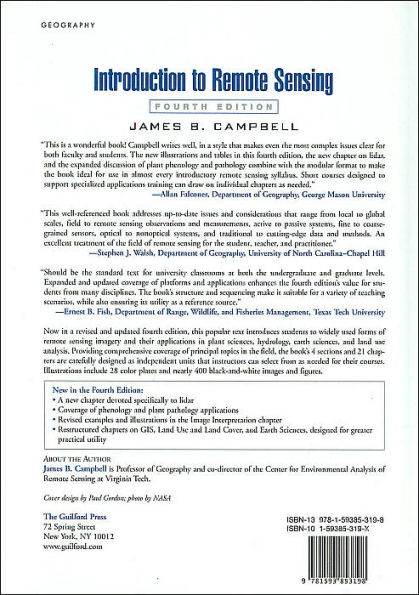
"The fourth edition of Introduction to Remote Sensing is a thorough and comprehensive description of fundamental issues in remote sensing, image acquisition alternatives, analytical approaches, and applications across the biophysical sciences. This well-referenced book addresses up-to-date issues and considerations that range from local to global scales, field to remote sensing observations and measurements, active to passive systems, fine to coarse-grained sensors, optical to non-optical systems, and traditional to cutting-edge data and methods. An excellent treatment of the field of remote sensing for the student, teacher, and practitioner."—Stephen J. Walsh, Department of Geography, University of North Carolina-Chapel Hill
"This outstanding overview of remote sensing is very readable, with clear explanations and excellent illustrations. The book provides a comprehensive survey of introductory topics, as well as a concise overview of more advanced issues. Campbell's geographic background is evident in the strong treatment of the spatial properties of images. This book will make an outstanding text for both undergraduate and graduate remote sensing classes. It also will serve as a terrific introduction to remote sensing for professionals interested in learning more about this rapidly changing field."—Tim Warner, Department of Geology and Geography, West Virginia University
"This is a wonderful book! Campbell writes well, in a style that makes even the most complex issues clear for both faculty and students. The new illustrations and tables in this fourth edition, the new chapter on lidar, and the expanded discussion of plant phenology and pathology combine with the modular format to make the book ideal for use in almost every introductory remote sensing syllabus. Short courses designed to support specialized applications training can draw on individual chapters as needed. The book provides a treasury of references to source material, including websites for data, ensuring it will be valuable to students long after the course in question is completed. I recommend this excellent text to everyone seeking a good understanding of remote sensing."—Allan Falconer, Department of Geography, George Mason University
"Introduction to Remote Sensing, Fourth Edition serves as an excellent reference for both students and professionals, providing comprehensive information about various aspects of this technology. Review questions at the end of each chapter reinforce important concepts and enhance the book's utility for the classroom. I would recommend this book as an essential resource for all remote sensing professionals."—Ramesh Sivanpillai, Wyoming Geographic Information Science Center and Department of Renewable Resources, University of Wyoming
"The fourth edition of Introduction to Remote Sensing should be the standard text for university classrooms at both the undergraduate and graduate levels. Expanded and updated coverage of platforms and applications enhances the text’s value for students from many disciplines. The book's structure and sequencing make it suitable for a variety of teaching scenarios, while also ensuring its utility as a reference source."—Ernest B. Fish, Department of Range, Wildlife, and Fisheries Management, Texas Tech University