
SE Virginia/Richmond to Hampton Roads VA Regional Map
Rand McNally's folded map for Southeast Virginia Richmond to Hampton Roads is a must-have for anyone traveling in and around this part of Virginia, offering unbeatable accuracy and reliability at a great price. Our trusted cartography shows all Interstate, U.S., state, and county highways, along with clearly indicated parks, points of interest, airports, county boundaries, and streets. The easy-to-use legend and detailed index make for quick and easy location of destinations. You'll see why Rand McNally folded maps have been the trusted standard for years. - Regularly updated. - Full-color maps. - Clearly labeled Interstate, U.S., state, and county highways. - Indications of parks, points of interest, airports, county boundaries, downtown & vicinity maps. - Major attractions & Golf Courses. - Enlargements of Norfolk and Portsmouth downtown, Richmond downtown, Virginia Beach downtown, Williamsburg, Colonial Williamsburg Historic Area, Richmond Int'l Airport, Newport News/Williamsburg Int'l Airport, Norfolk Int'l Airport. - Easy-to-use legend. - Detailed index & Major Street Index. Coverage Area: Chesapeake, Colonial Heights, Hampton, Hopewell, Newport News, Norfolk, Petersburg, Poquoson, Portsmouth, Richmond, Suffolk, Virginia Beach, West Point, Williamsburg. Product Details: Measures 9.5" x 4" and folds out to 40" x 28".
1145555660
SE Virginia/Richmond to Hampton Roads VA Regional Map
Rand McNally's folded map for Southeast Virginia Richmond to Hampton Roads is a must-have for anyone traveling in and around this part of Virginia, offering unbeatable accuracy and reliability at a great price. Our trusted cartography shows all Interstate, U.S., state, and county highways, along with clearly indicated parks, points of interest, airports, county boundaries, and streets. The easy-to-use legend and detailed index make for quick and easy location of destinations. You'll see why Rand McNally folded maps have been the trusted standard for years. - Regularly updated. - Full-color maps. - Clearly labeled Interstate, U.S., state, and county highways. - Indications of parks, points of interest, airports, county boundaries, downtown & vicinity maps. - Major attractions & Golf Courses. - Enlargements of Norfolk and Portsmouth downtown, Richmond downtown, Virginia Beach downtown, Williamsburg, Colonial Williamsburg Historic Area, Richmond Int'l Airport, Newport News/Williamsburg Int'l Airport, Norfolk Int'l Airport. - Easy-to-use legend. - Detailed index & Major Street Index. Coverage Area: Chesapeake, Colonial Heights, Hampton, Hopewell, Newport News, Norfolk, Petersburg, Poquoson, Portsmouth, Richmond, Suffolk, Virginia Beach, West Point, Williamsburg. Product Details: Measures 9.5" x 4" and folds out to 40" x 28".
9.99
In Stock
5
1


SE Virginia/Richmond to Hampton Roads VA Regional Map
2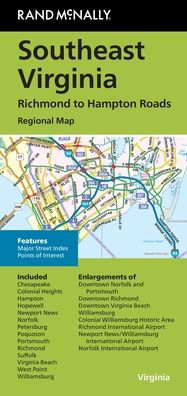
SE Virginia/Richmond to Hampton Roads VA Regional Map
2
$9.99
9.99
In Stock

Product Details
| ISBN-13: | 9780528028908 |
|---|---|
| Publisher: | Rand McNally |
| Publication date: | 05/24/2024 |
| Pages: | 2 |
| Product dimensions: | 4.00(w) x 9.00(h) x 0.25(d) |
From the B&N Reads Blog